Spain has one of the longest coastlines in the Mediterranean. The length of the Mediterranean coast of Spain is more than 1600 kilometers. This is one of the warmest and most favorable regions for summer holidays in Spain and Europe.
The Mediterranean coast of Spain extends from the city of Tarifa (the southernmost point of Europe) to the Cape of Cabo de Creus located in northeastern Spain (the border between Spain and France). Along the coast of Spain there is the N-340 motorway (Cádiz - Barcelona) and the AP-7 road (from the city of Algeciras to the border with France). Barcelona, Malaga, Alicante, Valencia and Seville airports are among the busiest in Spain. Some cities are accessible by high-speed rail.
The southern coast of Spain is located in the autonomous regions of Andalusia, Murcia, Valencia and Catalonia (listed from west to east). There are many cities and towns, historical and natural attractions, and many excellent beaches. Residents of many European countries spend their summer holidays here. (Coastal cities are also quite popular with digital nomads.)
Certain sections of the coast have their own names. Which place should you choose for your next vacation? Where to stay? How to get there? The map will help you figure out where it is.

See interactive map of the coast.
- Book your hotel in advance.
- Find a convenient flight to Spain.
- Book a transfer (taxi) from the airport to your hotel.
- Car rentals - book online.
- The best resorts on the Mediterranean coast in Spain.
![]() You might also be interested in: the Mediterranean coast of Turkey.
You might also be interested in: the Mediterranean coast of Turkey.
Visit Spain | Barcelona | Valencia | Malaga | Tarragona | Canary Islands | Events| Map
Andalusia
The autonomous region of Andalusia is located in southwestern Spain. Andalusia is administratively divided into eight provinces, four of which are located along the coast: Cadiz, Malaga, Granada, Almeria (named from west to east). Seville, Malaga, Cordoba, Granada are the largest cities in Andalusia.
This is the only region of Spain that borders both the Atlantic Ocean and the Mediterranean Sea. The Atlantic Ocean is located west of Andalusia. The Strait of Gibraltar and the Mediterranean Sea are to the south.
The coastline of Andalusia is approximately 840 kilometers long. The Atlantic coast of Andalusia is called the “Costa de la Luz”. "Costa del Sol", "Costa Tropical" and "Costa de Almeria" are sections of the Mediterranean coast.
Andalusia is one of the hottest regions in Europe. Andalusia has many great places for beach lovers, but not only. There are also a lot of interest for lovers of history, architecture, nature and sports. The historic centers of Úbeda and Baeza are included in the UNESCO World Heritage List. The southernmost ski resorts in Europe are located in the Sierra Nevada mountain region. Andalusia is the second most popular tourist region in Spain (after Catalonia). (Many tourists visiting Spain visit more than one regions during their trip.)
There are several airports in Andalusia. Málaga Airport is the busiest in the region. Seville Airport and Jerez Airport also serve quite a lot of tourists.
The Port of Malaga is the oldest continuously operating port in Spain. The port handles a large number of cruise ships every year. The port has berths for yachts too.
The high-speed railway connects Malaga, Seville, Cordoba, Granada, Cadiz with Madrid and other cities in Spain.
You can drive along the coast from Andalusia to France along the Autopista AP-7 motorway.
Hotels | Taxi | Flights | Guided tours | Car rentals | Events | Spanish cuisine
Costa de la Luz
The Costa de la Luz region is located in the west of Andalusia, on the Atlantic coast (southwest coast of Spain). The Costa de la Luz (Coast of Light) stretches from the Portuguese border in the north to the city of Tarifa and the Strait of Gibraltar in the south.
The region's climate is influenced by the Atlantic Ocean. It is not so hot here (thanks to the winds blowing from the ocean) and it rains a little more. Ocean waves and winds make Costa de la Luz a popular destination for lovers of water sports and outdoor activities. The proximity of the ocean makes this coast a good place for surfing, windsurfing, and kiting. There are also golf courses in the region. Tarifa is one of the best windsurfing destinations in Spain.
Popular destinations include Cadiz, Punta Umbria, Conil, Jerez de la Frontera, Isla Cristina, Rota and Zahara de los Atunes. The coastline has many good beaches for beach lovers.
The cities of Cadiz and Seville and the Doñana National Park (Parque Nacional de Doñana) are recommended for tourists to visit. The largest city on the coast is Cadiz. It is believed that this is the oldest city in Spain. Cadiz Airport is the most convenient for traveling to Costa de la Luz (Jerez Airport; IATA: XRY).
Visit Spain | Barcelona | Valencia | Malaga | Tarragona | Canary Islands | Events| Map
Costa del Sol
The Costa del Sol (Coast of the Sun) region is the southernmost part of the Mediterranean coast of Spain. The Costa del Sol is located between the Costa de la Luz and Costa Tropical regions, from the Strait of Gibraltar in the west to the Rock of Maro in the east.
This is a very popular stretch of the Mediterranean coast for summer holidays among residents of many European countries. It is believed that the most prestigious resorts in Spain are located here. Many celebrities, aristocrats and rich people have their villas on the Costa del Sol.
On this part of the coast there are such famous cities as Malaga, Marbella, Torremolinos, Benalmadena, Fuengirola, Mijas, San Pedro de Alcantara, Estepona, Manilva, Casares, Rincon de la Victoria, Velez-Malaga, Nerja, Frigiliana and Torrox. Popular water parks are located in the cities of Torremolinos and Fuengirola. Marbella was recently named the best destination of 2024!
Malaga is the main city of the Costa del Sol.
The port of Malaga receives a large number of cruise and passenger ships with tourists.
Malaga International Airport is one of the busiest in Spain. The airport has constant air connections with many European cities and airports in North America, Asia and Africa. The largest number of tourists comes from the UK.
Buses depart from Malaga bus station to many coastal cities, as well as to Portugal and France.
The railway connects the city of Malaga with the airport, the resort of Fuengirola and some other places on the coast. (It is planned to continue the railway to Marbella.)
(You can see location on the map.) I
Learn more about Costa del Sol.
Book your holiday on the Costa del Sol yourself, online.
Hotels | Taxi | Flights | Guided tours | Car rentals | Events
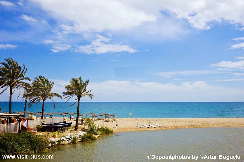
In the photo: one of the beaches in Marbella (Playa Rio Verde).
Costa da la Luz is to the west and Costa Tropical is to the east of the Costa del Sol.
Costa Tropical
The Costa Tropical region is located in Andalusia, in the province of Granada, between the Costa del Sol and the Costa de Almeria. The Costa Tropical coastline is more than 100 kilometers long and stretches at the foot of the Sierra Nevada mountains from La Rabita in the east to La Herradura in the west.
The Sierra Nevada mountain range influences the region's climate. There is more rainfall here than in the Malaga area. Winters on this coast are warmer, and summers are not as hot as on the Costa del Sol.
Almunecar and Motril are the most famous cities on the coast. There are also interesting places on the coast for history buffs: rock paintings in caves near the city of Nerja, ruins from the times of the Roman Empire. One of the residences of the King of Spain is located near the city of Motril.
The city of Granada is the administrative and cultural center of the province. There is an airport near Granada (Federico García Lorca Granada-Jaén Airport; GRX), but tourists can use Malaga and Almeria airports as well.
Create your own holiday package: accommodation, airport transfer, flights, guided tours, Car rentals.
Costa de Almería
The Costa de Almeria region is located in the southeast of Andalusia. The coastline of the Costa de Almeria is more than 210 kilometers long.
There are many good beaches and hotels on the Costa de Almeria.
Roquetas de Mar is the most popular tourist town in the province of Almeria. This city has about 15 kilometers of coastline. Some beaches are marked with a blue flag.
The coastal town of Mojácar also has several good beaches (Mojacar Playa).
The Cabo de Gata-Níjar National Park is the largest protected natural coastal area in Andalusia.
The Alcazaba of Almeria is the region's most famous historical landmark.
There is an international airport at Almeria (IATA: LEI).
🌡 You can find out the water and air temperature at some beaches here.
Murcia
The Autonomous Community of Murcia (Región de Murcia) is located in the south of Spain, between Andalusia and Valencia.
Weather in Murcia now
The city of Murcia, the administrative center of the region, is located approximately 45 kilometers from the coast. The main attraction of the city is its Cathedral. The most popular towns in the Murcia region are also Cartagena, Lorca and Caravaca de la Cruz. The Ancient Roman Theater of Cartagena is the most visited monument and museum space in the region.
The coast of the Murcia region has a Mediterranean climate with warm winters and hot summers. The number of sunny days per year is on average about 300. In January (the coldest month of the year) the air can warm up to 16°C. In August (the warmest month of the year) daytime temperatures often exceed 30°C. There are very few rainy days.
The international airport of the Murcia region (IATA: RMU), is located at a distance of 25 kilometers from the city of Murcia and 28 kilometers from Cartagena. Alicante Airport (ALC) is also nearby, at a distance of approximately 60 kilometers from Murcia and 120 kilometers from Cartagena.
The railway connects the region with the cities of Madrid and Alicante.
The Mediterranean coast in the Murcia region is called “Costa Cálida” (Warm Coast).
Delicious, local food is an important part of the travel experience. Get your gastronomic adventure in Spain.
Costa Calida
The Costa Calida coast is about 200 kilometers long and stretches from the village of El Mojon in the northeast (near the Mar Menor) to the town of Cuatro Calas in the southwest (municipality of Águilas).
The Costa Cálida has many good beaches, many of which are awarded the Spanish tourist quality mark "Q". Part of the coast is a rocky shore. The region has well-developed services designed for tourists: boat and bus excursions, diving and golf.
The main natural attraction of the coast is the largest natural salt lake in Europe - “Mar Menor” (translated as “small sea”). The Mar Menor lagoon is separated from the sea by a narrow sandy strip (about 22 kilometers) long, which is called “La Manga”. The Mar Menor has been declared a protected natural area. The Arenales de San Pedro del Pinatar Natural Park is located nearby.
To the west of the Costa Calida is the resort region of Costa de Almeria (Andalusia), to the east is the resort region of Costa Blanca (Valencia).
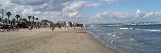
Valencia
The region of Valencia (Comunidad Valenciana) is located in eastern Spain. The region is divided into three provinces: Alicante (Alacant), Castelló and Valencia. The coastline in Valencia is approximately 520 km long. The Valencian coast is usually divided into three zones: Costa Blanca, Costa de Valencia and Costa del Azahar. The city of Valencia is the administrative center of the region.
Weather in Valencia
Valencia is located in the Mediterranean climate zone, but the weather on the southern part of the coast (the cities of Benidorm, Alicante) is drier and hotter than on the northern part. Winter on the northern coast of Valencia is somewhat cooler than on the southern one. The greatest amount of rain falls in spring and autumn.
In January, maximum daytime temperatures in the Valencia region range from 10 to 20°C. In August, the air warms up above 30°C during the day. The sea temperature in August is about 25°C.
Valencia has a large number of architectural monuments and museums that will be interesting for tourists to visit.
The most famous events in the region:
- The Fallas Festival takes place annually in Valencia from 14 to 19 March.
- The Tomatina Festival takes place on the last Wednesday of August in Buñol.
There are three international airports in the Valencian Community:
- Alicante International Airport (Alicante-Elche Airport, IATA: ALC) is the sixth largest airport in Spain by number of passengers. The airport serves tourists from the regions of Valencia and Murcia. The airport is located at a distance of 9 kilometers from the city of Alicante, approximately 160 kilometers from the city of Valencia, approximately 70 kilometers from the city of Murcia.
- Valencia Airport (also known as Manises Airport, IATA: VLC) is located 8 kilometers from the city of Valencia. In 2011, Valencia Airport served approximately 5 million passengers.
- Castellon Airport (IATA: CDT) receives a small number of flights.
Seaport of Valencia is one of the largest ports in Spain and the Mediterranean Sea. Port serves a large number of cruise ships during the tourist season. Passenger ships from the port of Valencia go to the Balearic Islands (Ibiza, Majorca), in Italy and in other ports of Spain. In the cruise terminal is located a tourist information point (Tourist-Info Puerto). The port is located at a distance about 5 kilometers from the city center. The nearest metro station is “Grau Canyamelar” (Plaza Armada Española).
Visit Spain | Barcelona | Valencia | Malaga | Tarragona | Canary Islands | Events| Map
Costa Blanca
Look for holiday homes and hotels in Spain here.
The Costa Blanca region (White Coast) is a stretch of the Mediterranean coast of Valencia, in the province of Alicante, between the cities of Denia in the north and Pilar de la Horadada in the south. The length of the Costa Blanca coastline is about 200 kilometers. Approximately half the length of the coastline is occupied by beaches. The largest number of tourists come here from the UK and Germany. Benidorm, Alicante, Denia, Javea, Torrevieja are the most popular tourist cities on the Costa Blanca. There is a regular bus service along the Costa Blanca.
In the northern part of the coast (Marina Alta) there are many rocky places near the beaches. The most popular beaches, such as Levante, Poniente and Malpas, are located in the central part of the coast (near the city of Benidorm). There are also many beautiful long sandy beaches in the southern Costa Blanca. Benidorm is often called the capital of the Costa Blanca. The popular Aqualandia water park and Terra Mitica amusement park are located in Benidorm.
Costa de Valencia is located to the east, and Costa Cálida is to the west of the Costa Blanca.
Costa de Valencia
"Costa de Valencia" is the central section of the coast of Valencia. Very often it is referred to as the “Costa Blanca” or “Costa del Azhar”. Valencia, Oliva, Sagunto, Gandia, Cullera are the cities on this stretch of coast.
Near the city of Valencia there are the beaches of Playa de las Arenas, Malvarrosa, El Cabanyal, Pinedo Beach, L'Arbre del Gos, and Malvarrosa. You can get to the beaches by bus from Plaza de la Reina.
Costa del Azahar
Costa Azahar (or Orange Blossom Coast) is a stretch of Mediterranean coast in the province of Castellon, from Vinaròs to Almenara. The length of the Costa del Azahar coast is approximately 120 kilometers. Sometimes the name Costa dels Tarongers (Coast of Orange Trees) is used. The settlements of Peníscola, Benicàssim and Castelló de la Plana are located on this stretch of coastline.
Previously, the name Costa del Hazard also extended to the coast of the province of Valencia, but nowadays the region of the city of Valencia is promoted by the tourist world under the name Costa de Valencia.
Create your own holiday package: accommodation, airport transfer, flights, guided tours, Car rentals.
Catalonia
The Autonomous Community of Catalonia (Cataluña) is located in northeastern Spain. To the north of Catalonia is France, to the west is Valencia, and to the southeast is the Mediterranean Sea. The administrative center of Catalonia is the city of Barcelona. The cities of Tarragona, Lleida, Girona, Manresa, Igualada, Martorell, Terrassa and Sabadell are also often visited by tourists. Catalonia attracts a large number of tourists due to its large number of attractions, many good beaches and warm climate.
Barcelona Airport is the second largest airport in Spain by the number of passengers served.
Girona and Reus airports also serve many tourists.
The ports of Barcelona and Tarragona receive cruise ships during the tourist season.
The length of the coastline in Catalonia is approximately 580 kilometers. Costa Brava and Costa Daurada are sections of the Mediterranean coast in Catalonia, near Barcelona.
Weather in Barcelona.
The weather in summer and early autumn on the Mediterranean coast in Catalonia is favorable for beach lovers. In summer, air temperatures often rise to 30°C and above. The sea temperature near Barcelona in August is about 25°C.
Winter on the coast is quite warm. Winter temperatures along the coast average around 10°C.
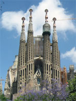
Barcelona
Barcelona is the capital of the autonomous region of Catalonia, the second most populous city in Spain. The distance from Barcelona to the border with France is approximately 120 kilometers. It is one of the most popular by tourist’s cities in Europe, the most popular city in Spain and It is one of the most visited cities on Mediterranean Sea shores.
 “Barcelona - El Prat Airport” (Aeroport de Barcelona - el Prat, Barcelona Airport) is located at a distance about 12 kilometers south-west from the Barcelona. It is the second largest airport by passenger traffic in Spain (after Madrid Barajas Airport). Learn more.
Girona-Costa Brava Airport (Aeropuerto de Girona-Costa Brava) is located in the northeast part of Catalonia, approximately 12 kilometers from the Girona city. Distance from the airport to Barcelona is 90 kilometers.
Reus Airport is located approximately 7.5 kilometers from the city of Tarragona, in the Costa Daurada resort region. The airport serves a large number of tourists arriving at the nearest coastal resorts.
Costa Dorada
The Costa Dorada region (Golden Coast) is located in the southwestern part of Catalonia, in the province of Tarragona. Tarragona is the largest city on the Costa Dorada.
The total length of the Costa Dorada is approximately 90 kilometers, from the city of Vilanova i la Geltru to Valencia. Sandy beaches alternate with areas of rocky shore. The coast is protected from northern winds by mountains (the Pyrenees and the Catalan Mountains). It is believed that the Costa Dorada is well suited as a summer holiday destination for families with children.
The main tourist centers of the region are Tarragona, Salou, Calafell, La Pineda Platja, Miami Platja and El Vendrell. There is a wide selection of hotels, restaurants, and entertainment venues. The region promotes itself in the tourism market as a place for sports (water sports, golf), for lovers of gastronomic and wine tourism. For lovers of a relaxing holiday, the places southwest of the city of Salou may be better suited (there are fewer tourists and entertainment here).
There are several amusement parks in the Costa Dorada region: PortAventura, Aqualeon (in Albinyana), Aquopolis (in La Pineda). There is a national reserve "Delta del Ebro" in the south of the Costa Dorada (Delta of the Ebro River).
Tarragona
The city of Tarragona is located in the southwestern part of Catalonia, on the shores of the Mediterranean Sea. The city's population is approximately 140 thousand people. The distance from the city of Tarragona to Barcelona is 98 kilometers. In and near the city there are interesting sights from the times of the Roman Empire (an amphitheater, an aqueduct and others). Reus Airport is located approximately 7.5 kilometers from the city of Tarragona.
Costa del Garraf
“Costa del Garraf” coast is located to southwest of the Barcelona, between the mouth of the Llobregat river (next to the airport) and the “Vilanova i la Geltru” town. To west of this region is located Costa Dorada resort coast, to east is located the Barcelona city. This small part of coast was often named as part of the Costa Dorada coast.
In the resort region “Costa del Garraf” are located many sandy beaches, many of which have flat bottom. Among the best beaches are called (from west to east): Platja del Prat (El Prat de Llobregat), Gavà Mar (Gavà), Platja de Castelldefels, Platja de Ribes-Roges (Vilanova i la Geltrú), Platja d 'Adarró (Vilanova i la Geltrú), Platja de Sant Gervasi (Vilanova i la Geltrú), Platja Llarga (Cubelles).
Gava, Castelldefels, Sitges and “Vilanova i la Geltru” are the most famous towns on the coast.
The city of Sitges is located 35 kilometers southwest of Barcelona. This is a very popular coastal town. Good sandy beaches arbe available within the city area. You can get to Barcelona by rail or bus.
Costa Brava
The northern part of the Mediterranean coast of Spain is called Costa Brava. The Costa Brava resort coast is approximately 160 kilometers long, from the city of Blanes to the border with France. Rocky areas of the coast alternate with small bays and beaches. The best time to travel to the Costa Brava is from May to mid-September.
Lloret de Mar is the largest and most popular town on the Costa Brava and one of the most visited places on the Mediterranean coast of Spain. Lloret de Mar is located in the province of Girona, 75 km north of Barcelona.
The city of Girona is located about 100 kilometers from Barcelona and about 30 kilometers from the sea. This is one of the largest cities in the region. About one hundred thousand people live in the city. The city is the administrative center of the province of Girona. The journey from Barcelona to Girona takes just over 1 hour. Girona-Costa Brava Airport is located approximately 10 kilometers from the city.
Distance from Girona to Toulouse (France) is about 300 km, to the city of Montpellier (France) - 250 kilometers (distance by road) and to Cannes - 540 km.
Visit Spain | Barcelona | Valencia | Malaga | Tarragona | Canary Islands | Events| Map
Barcelona | Valencia | Malaga | Tarragona | Canary Islands | Events| Map
👉 See also: the best resort hotels on the Mediterranean coast in Spain.
- Choose and book your hotel.
- The best resort hotels on the Mediterranean coast in Spain.
- Find flights and buy tickets.
- Guided tours in Barcelona.
- The French Riviera is a great place to spend a vacation.
- Turkey Mediterranean coast.
Maybe you want to go on vacation to Mexico, Dominican Republic, Las Vegas or Miami?